Page 2 of 2
Re: Solar Data script : Azimuth, Altitude, Lux
Posted: Sunday 02 January 2022 10:33
by renerene
what about an update regarding
Code: Select all
Status: dzVents: !Info: SOLAR 3: Function math.pow(x, y) has been deprecated in Lua 5.3. Please consider changing code to x^y
?
Re: Solar Data script : Azimuth, Altitude, Lux
Posted: Sunday 02 January 2022 11:00
by jmleglise
Hi,
Version 3.1 already includes (since v1.5) the necessary adaptations.
Code: Select all
function math.pow(x, y)                                         -- Function math.pow(x, y) has been deprecated in Lua 5.3.
	return x^y
end
Re: Solar Data script : Azimuth, Altitude, Lux
Posted: Sunday 06 March 2022 23:27
by hestia
The luminance given in the original script is considered on the floor (horizontal projection of the sun radiation or measured on an horizontal surface).
For a window, vertical or on a roof, what is needed is the projection of the luminance on the normal of the considered surface.
As the luminance given by the script is the sum of the direct and the scattered luminance, it is not possible to apply the projection, because the scattered luminance is a any direction.
That's why I propose a new version of this script, that gives separate values for direct and scattered luminances, so that we could calculate the right value on a surface with any slope.
Code: Select all
--[[
W: Weather script

	Prerequisites
	==================================
	Requires dz v2020 or later

	SolarData: real-time solar data

	from:
	https://easydomoticz.com/forum/viewtopic.php?f=17&t=1340
	https://www.domoticz.com/forum/viewtopic.php?p=148904#p148904
	https://domoticz.com/forum/viewtopic.php?f=72&t=35541
	https://www.domoticz.com/wiki/index.php?title=Lua_dzVents_-_Solar_Data:_Azimuth_Altitude_Lux

-- Authors  ----------------------------------------------------------------
	V1.0 - Sébastien Joly - Great original work
	V1.1 - Neutrino - Adaptation to dz
	V1.2 - Jmleglise - An acceptable approximation of the lux below 1° altitude for Dawn and dusk + translation + several changes to be more userfriendly.
	V1.3 - Jmleglise - No update of the Lux data when <=0 to get the sunset and sunrise with lastUpdate
	V1.4 - use the API instead of updateDevice to update the data of the virtual sensor to be able of using devicechanged['Lux'] in our scripts. (Due to a bug in dz that doesn't catch the devicechanged event of the virtual sensor)
	V1.5 - xces - UTC time calculation.
	V2.0 - BakSeeDaa - Converted to dzVents and changed quite many things.
	V2.4.1-DarkSky - oredin - Use Dark Sky API instead of WU API

	19/05/2019 - hestia - sources independent: use sensor with input values for CloudCover and Pressure
	06/11/2019 - hestia - function math.pow(x, y) has been deprecated in Lua 5.3. => changing code to x^y
	10/01/2002 - hestia - latitude and Longitude from settings - option to stop the script if lux and radiation not needed
	07/02/2021 - hestia - modify the logging
	22/02/2021 - hestia - from a cloud cover device instead of okta, remove the stop of the script (see 10/01/2002)
	05/11/2021 - hestia - add a radiation device for the radiation no cloud, on the floor

	25/02/2021 - hestia - checked with 	V3.1 (14/02/2021) - Jmleglise = Merge the different fork. Some clean Up, comment and wiki

    19/08/2021 - hestia - add several radiation devices to have direct and scattered, with (weighted) or w/o cloud impact radiation separate, in order to calcultate the radiation on a surface with any angle from the ground.
    The result given previously for the radiation was on the ground only, so not usable for a window (vertical) or a roof (w an angle).
    Change the formula of the coefficient of mitigation M, to avoid the requirement of the pressure (no longer needed this weather info: more simple)
    https://www.ftexploring.com/solar-energy/air-mass-and-insolation1.htm#fn1
    + refactoring of some parts
    02/03/2021 - hestia - some cleaning et comments

--]]

-- Variables to customize ------------------------------------------------

-- Triggers of the script to choose
local idxCloudCover = 1913       -- device holding cloud coverage in percentage. Ex : 60%  (for e.g. a device from Openweathermap...)
local intervalMins = 5      	 -- the interval of running this script. No need to be faster than the data source. (For example it is 10 min)
--local TEST = 204               -- a dummy switch for testing w/o waiting minutes / remove comment to use / comment to ignore

------
------  Dummy devices to save result (idx or 'name') (to create w dz GUI)  ------
-- Custom Sensor SubType
local idxSolarAzimuth = 337     -- Azimuth of the sun
local idxSolarAltitude = 338	-- Altitude of the sun

-- total radiation with cloud impact, on the floor => the values saved with the V3.1
local idxRadiation = 304            -- Solar Radiation SubType (W/m2)
local idxLux = 305                  -- Lux Type (Lux)

-- additional values from V3.1 - Solar Radiation SubType (W/m2)
local idxRadiationDirect = 1914     -- direct radiation with cloud impact, if no incidence
local idxRadiationScattered = 1915  -- scattered radiation with cloud impact
local idxRadiation0 = 1916          -- total radiation with cloud impact, if no incidence

-- radiation without cloud impact, on the floor (with incidence = 90° - sun altitude)
local idxRadiationNoCloud = 1970    -- solar Radiation (in Watt/m2)
--local idxRadiationNoCloudCustom = 1764  -- custom sensor for Solar Radiation  (in Watt/m2) => to choose one of both
------

-- Parameters to give
-- Latitude and Longitude: custon values for this script ; if empty (nul) values from domoticz settings are taken
local script_latitude   -- Latitude (Decimal number) Decimal Degrees ; something like 51.748485
local script_longitude  -- Longitude (Decimal number) Decimal Degrees ; something like 5.629728
local LocalAltitude = 87	-- Altitude. (Integer) Meters above sea level

-- How to convert Lux to W/m2
-- "There is no simple conversion...it depends on the wavelength or color of the light
-- However, for the SUN, there is an approximate conversion of 0.0079 W/m2 per Lux"
-- see InverseSquareLawPresentation.pdf https://studyres.com/doc/16229818/light-vs.-distance p32
local LuxToWm2 = 0.0079

-- Logging to choose
local LOG_DEBUG = 0         -- 0 =>ERROR / 1 => FORCE / 2 => DEBUG
local LOG_LEVEL
local LOGGING
if LOG_DEBUG == 2 then
    LOGGING = domoticz.LOG_DEBUG
    LOG_LEVEL = domoticz.LOG_DEBUG
elseif LOG_DEBUG == 1 then
    LOGGING = domoticz.LOG_FORCE
    LOG_LEVEL = domoticz.LOG_FORCE
else
    LOGGING = domoticz.LOG_ERROR
    LOG_LEVEL = domoticz.LOG_INFO
end

return {
    logging =   {
                level =   LOGGING
                },
	on =        {
        		--devices = {idxCloudCover},
	        	devices = {TEST},
		        timer = {'every '..tostring(intervalMins)..' minutes'}
	            },

	execute = function(dz, item, triggerInfo)
        _G.logMarker =  dz.moduleLabel -- set logmarker to scriptname
    	local _u = dz.utils

    	local function leapYear(year)
			return year%4==0 and (year%100~=0 or year%400==0)
		end

        local latitude
        if script_latitude ~= nil then
            latitude = script_latitude
        else
            latitude = dz.settings.location.latitude
        end

        local longitude
        if longitude ~= nil then
            longitude = script_longitude
        else
            longitude = dz.settings.location.longitude
        end

		local arbitraryTwilightLux = 6.32 -- W/m² egal 800 Lux (the theoritical value is 4.74 but I have more accurate result with 6.32...) /!\
		local constantSolarRadiation = 1361 -- Solar Constant W/m²

		local year = os.date('%Y')
		local numOfDay = os.date('%j')
		local nbDaysInYear = (leapYear(year) and 366 or 365)

		local angularSpeed = 360/365.25
		local declination = math.deg(math.asin(0.3978 * math.sin(math.rad(angularSpeed) *(numOfDay - (81 - 2 * math.sin((math.rad(angularSpeed) * (numOfDay - 2))))))))
		local timeDecimal = (os.date('!%H') + os.date('!%M') / 60) -- Coordinated Universal Time  (UTC)
		local solarHour = timeDecimal + (4 * longitude / 60 )    -- The solar Hour
		local hourlyAngle = 15 * ( 12 - solarHour )          -- hourly Angle of the sun
		local sunAltitude = math.deg(math.asin(math.sin(math.rad(latitude))* math.sin(math.rad(declination)) + math.cos(math.rad(latitude)) * math.cos(math.rad(declination)) * math.cos(math.rad(hourlyAngle))))-- the height of the sun in degree, compared with the horizon

		local azimuth = math.acos((math.sin(math.rad(declination)) - math.sin(math.rad(latitude)) * math.sin(math.rad(sunAltitude))) / (math.cos(math.rad(latitude)) * math.cos(math.rad(sunAltitude) ))) * 180 / math.pi -- deviation of the sun from the North, in degree
		local sinAzimuth = (math.cos(math.rad(declination)) * math.sin(math.rad(hourlyAngle))) / math.cos(math.rad(sunAltitude))
		if sinAzimuth<0 then azimuth=360-azimuth end
		local sunstrokeDuration = math.deg(2/15 * math.acos(- math.tan(math.rad(latitude)) * math.tan(math.rad(declination)))) -- duration of sunstroke in the day . Not used in this calculation.
		local RadiationAtm = constantSolarRadiation * (1 +0.034 * math.cos( math.rad( 360 * numOfDay / nbDaysInYear ))) -- Sun radiation  (in W/m²) in the entrance of atmosphere.

		-- Coefficient of mitigation M
        MM0 = math.exp(-0.0001184 * LocalAltitude)
		--dz.log('MM0: ' .. MM0, LOG_LEVEL)
        -- https://www.ftexploring.com/solar-energy/air-mass-and-insolation1.htm#fn1

		local sinusSunAltitude = math.sin(math.rad(sunAltitude))
		local M0 = math.sqrt(1229 + (614 * sinusSunAltitude)^2) - 614 * sinusSunAltitude
		local M = M0 / MM0

  		dz.log('triggerInfo = ' .. triggerInfo.type, LOG_LEVEL)
		dz.log('Latitude = ' .. latitude .. ', Longitude: ' .. longitude, LOG_LEVEL)
		dz.log('Local Altitude = ' .. tostring(LocalAltitude) .. ' m', LOG_LEVEL)
		dz.log('Angular Speed = ' .. angularSpeed .. ' per day', LOG_LEVEL)
		dz.log('Declination = ' .. declination .. '°', LOG_LEVEL)
		dz.log('Universal Coordinated Time (UTC) = '.. timeDecimal ..' H.dd', LOG_LEVEL)
		dz.log('Solar Hour = '.. solarHour ..' H.dd', LOG_LEVEL)
		dz.log('Altitude of the sun = ' .. _u.round(sunAltitude,0) .. '°', dz.LOG_FORCE)
		dz.log('Angular hourly = '.. hourlyAngle .. '°', LOG_LEVEL)
		dz.log('Azimuth of the sun = ' .. _u.round(azimuth,0) .. '°', dz.LOG_FORCE)
		dz.log('Duration of the sun stroke of the day = ' .. _u.round(sunstrokeDuration,2) ..' H.dd', LOG_LEVEL)
		dz.log('Radiation max in atmosphere = ' .. _u.round(RadiationAtm,2) .. ' W/m²', LOG_LEVEL)
		dz.log('Coefficient of mitigation M = ' .. M ..' M0 = '..M0, LOG_LEVEL)

        -- Save the results : sun azimuth and altitude
		dz.devices(idxSolarAzimuth).updateCustomSensor(_u.round(azimuth,0))
		dz.devices(idxSolarAltitude).updateCustomSensor(_u.round(sunAltitude,0))

        local cloudPercentage = dz.devices(idxCloudCover).percentage

    	local okta = cloudPercentage / 12.5
		local Kc = 1 - 0.75 * ((okta / 8)^3.4)  -- Factor of mitigation for the cloud layer

		dz.log('Okta = '.. okta, LOG_LEVEL)
		dz.log('Kc = ' .. Kc, LOG_LEVEL)

		local directRadiation, directRadiationFloor, scatteredRadiation

		if sunAltitude > 1 then -- Below 1° of Altitude , the formulae reach their limit of precision.
			directRadiation = RadiationAtm * (0.6^M) -- no take into account the slope of the target
			directRadiationFloor = directRadiation * sinusSunAltitude -- sinusSunAltitude = the cosinus of incidence (the floor is horizontal)
			scatteredRadiation = RadiationAtm * (0.271 - 0.294 * (0.6^M)) * sinusSunAltitude  -- this sinus is not the incidence, no incidence effect: "scattered"
		elseif sunAltitude <= 1 and sunAltitude >= -7  then -- apply theoretical Lux of twilight
			directRadiation = 0
			directRadiationFloor = 0
			scatteredRadiation = arbitraryTwilightLux-(1-sunAltitude)/8*arbitraryTwilightLux -- in scatteredRadiation to simplify the code
		elseif sunAltitude < -7 then  -- no management of nautical and astronomical twilight...
			directRadiation = 0
			directRadiationFloor = 0
			scatteredRadiation = 0
		end

		local totalRadiationFloor, weightedTotalRadiationFloor, weightedDirectRadiation, weightedScatteredRadiation, weightedTotalRadiation

		totalRadiationFloor =  directRadiationFloor + scatteredRadiation -- radiation on the floor if no cloud

        weightedTotalRadiationFloor = totalRadiationFloor * Kc -- with cloud impact: what could give a weather station (sensor horizontal)
		local weightedLux = _u.round(weightedTotalRadiationFloor / LuxToWm2, 0)  -- Radiation in Lux

		weightedTotalRadiationFloor = _u.round(weightedTotalRadiationFloor,0)
		totalRadiationFloor =  _u.round(totalRadiationFloor, 0) -- radiation on the floor if no cloud

        weightedDirectRadiation = _u.round(directRadiation * Kc, 0) -- cloud, no incidence
        weightedScatteredRadiation = _u.round(scatteredRadiation * Kc,0) -- cloud, incidence no matters
		weightedTotalRadiation = _u.round((directRadiation + scatteredRadiation) * Kc, 0) -- cloud, no incidence

        -- with no incidence with the target
		dz.log('Scattered Radiation = '.. _u.round(scatteredRadiation,0) ..' W/m²', LOG_LEVEL)
		dz.log('Scattered Radiation with Cloud impact = '.. weightedScatteredRadiation..' W/m²', LOG_LEVEL)	-- (Scattered Radiation) * Kc
		dz.devices(idxRadiationScattered).updateRadiation(weightedScatteredRadiation)

		dz.log('Direct Radiation = '.. _u.round(directRadiation,0) ..' W/m²', LOG_LEVEL)
		dz.log('Direct Radiation with Cloud impact = '.. weightedDirectRadiation..' W/m²', LOG_LEVEL) -- (Direct Radiation Floor) * Kc
		dz.devices(idxRadiationDirect).updateRadiation(weightedDirectRadiation)

		dz.log('Total Radiation with Cloud impact = '.. weightedTotalRadiation..' W/m²', dz.LOG_FORCE) -- (Direct Radiation + Scattered Radiation) * Kc
		dz.devices(idxRadiation0).updateRadiation(weightedTotalRadiation)

        -- projection on the floor
		dz.log('Direct Radiation Floor = '.. _u.round(directRadiationFloor,0) ..' W/m²', LOG_LEVEL)	-- 	Direct Radiation * sinus(SunAltitude)
		dz.log('Total Radiation Floor = ' .. totalRadiationFloor ..' W/m²', LOG_LEVEL) -- Direct Radiation Floor + Scattered Radiation
		if idxRadiationNoCloud ~= nil then
	        dz.devices(idxRadiationNoCloud).updateRadiation(totalRadiationFloor)
	    end
		if idxRadiationNoCloudCustom ~= nil then
	        dz.devices(idxRadiationNoCloudCustom).updateCustomSensor(totalRadiationFloor)
	    end

        -- projection on the floor with cloud impact (weighted by Kc)
		dz.log('Total Radiation Floor with Cloud impact = '.. weightedTotalRadiationFloor..' W/m²', LOG_LEVEL) -- (Total Radiation Floor) * Kc
		dz.devices(idxRadiation).updateRadiation(weightedTotalRadiationFloor)

		dz.log('Total Radiation Floor with Cloud impact = '.. weightedLux ..' Lux', LOG_LEVEL) -- (Total Radiation Floor) * Kc converted in Lux
		-- No update if Lux is already 0. So lastUpdate of the Lux sensor will keep the time when Lux has reached 0.
		-- (Kind of timeofday['SunsetInMinutes'])
		if dz.devices(idxLux).lux + weightedLux > 0 then
			dz.devices(idxLux).updateLux(weightedLux)
		end

	end
}
A script that uses this values is given here
blinds move on the sun
Re: Solar Data script : Azimuth, Altitude, Lux
Posted: Monday 20 June 2022 18:52
by willemd
Thanks for a great script.
For the benefit of any newbies like me: the script tries to pick up latitude and longitude from the settings. If this does not work and it returns 0 for both latitude and longitude, then you have to allow 127.0.0.1. in the settings,system,local networks(no username/password)
This is explained in the dzvents documentation, but it is not the default in a new domoticz installation and it took me some time to find the reason why my latitude and longitude was zero and all calculations came out wrong.
Re: Solar Data script : Azimuth, Altitude, Lux
Posted: Wednesday 22 June 2022 15:50
by willemd
I am trying to use this script to arrive at a theoretical performance of my PVpanel installation and to then compare this to actual performance.
I am using the formula's as described on this website
https://pvpmc.sandia.gov/modeling-steps ... rradiance/ in addition to your formula's in the script.
I also have a device with "Sunpower" value in Watt/m2 from a nearby weatherstation, which I assume is the Direct Normal Irradiance DNI, measured on a surface perpendicular to the sun beam, and therefore already incorporating cloud cover effect. Using your sun altitude and azimuth calculation and the angle and azimuth of my PV installation, I can easily calculate the beam irradiance.
(I am so far not using the openweathermap cloud coverage since it is very inaccurate)
So now I want to add both ground and sky irradiance to the beam irradiance to arrive at a total (and find out whether these are factors of significance). The formula's for ground and sky irradiance use GHI (global horizontal irradiance), which can also be expressed in terms of DHI (diffuse horizontal irradiance) and DNI (direct normal irradiance).
The missing value in my data therefore seems to be the DHI.
Looking at your script I see two calculations I don't understand:
M0=math.sqrt(1229 + math.pow(614 * sinusSunAltitude,2)) - 614 * sinusSunAltitude
scatteredRadiation=RadiationAtm * math.pow(0.6,M) * sinusSunAltitude
note I live at sea level so altitude=0 and therefore M=M0
Can you explain those two calculations?
Any idea how I could approximate the DHI? Is this equal to your scatteredRadiation?
Re: Solar Data script : Azimuth, Altitude, Lux
Posted: Wednesday 22 June 2022 22:55
by hestia
Hi willemd
first of all, I not at the beginning of this topic and perhaps others could add to my answer.
I've just modified a formula to avoid the requirement of the pressure (no longer needed this weather info: more simple)
So the M0 was there before my last modification
As there are several formula about the radiation calculation I chose this one here
https://hal.archives-ouvertes.fr/hal-00835902
https://hal.archives-ouvertes.fr/hal-00835902/document
Piedallu_2007_AFS_version_HAL.pdf p 8
I also have a device with "Sunpower" value in Watt/m2 from a nearby weatherstation, which I assume is the Direct Normal Irradiance DNI, measured on a surface perpendicular to the sun beam, and therefore already incorporating cloud cover effect. Using your sun altitude and azimuth calculation and the angle and azimuth of my PV installation, I can easily calculate the beam irradiance.
If your info is from a weather station, from what I saw on the doc of some of them, the sensor in horizontal, so it is not the direct normal radiance, but the full radiance on a horizontal area.
You could not calculate the beam radiation from a radiation given by a weatherstation because
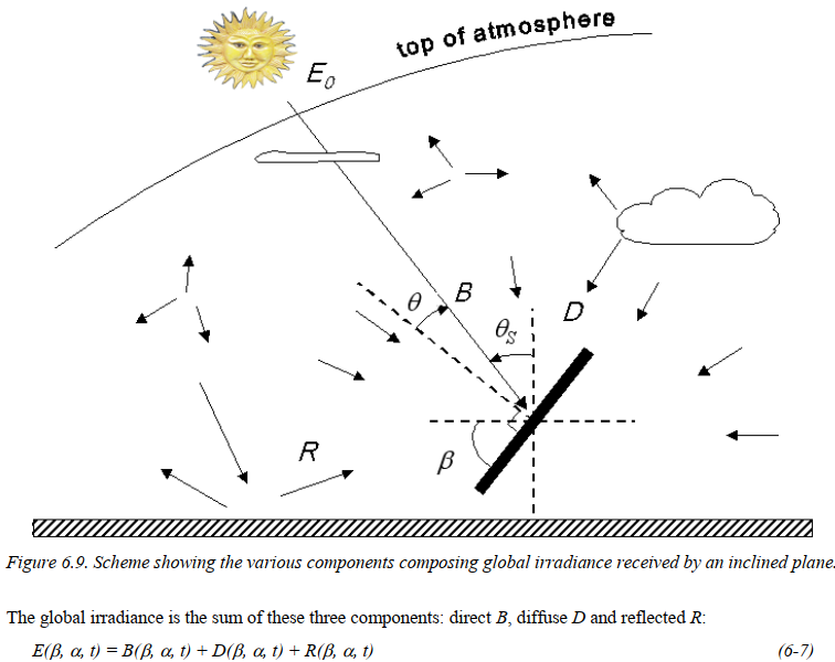
The full radiation is the addition of: direct B, diffuse D and reflected R (I kept the "scattered" term for diffuse) and only B and R are in "one" direction. So you could not make a projection on the D ; and the B and R do not have the same angle from the area
https://hal-mines-paristech.archives-ou ... ald_v1.pdf
- Screenshot 2022-06-22 224002.png (89.76 KiB) Viewed 4983 times
In that formula I don't see
GHI (global horizontal irradiance)
DHI (diffuse horizontal irradiance)
As I think they are calculated values from a formula regarding a specific application of your web site.
Regarding your objective
theoretical performance of my PVpanel installation and to then compare this to actual performance
you could have a look at this script
blinds move on the sun
There is a function GetSunRadiation that could give the radiation on an area of a sun panel (if you keep this formula)
Code: Select all
math.max(_u.round(F_solarRadiation * F_cosIncidence + F_solarRadiationScattered, 0), 0)
Except that in the solar data script the reflected radiation is not considered. For my use, as my windows are high or on the roof, I've not reflected radiation, and also it's difficult because it depends on the type of ground!
If your sun panels are on a roof or near one from another perhaps the reflected radiation in low
(I am so far not using the openweathermap cloud coverage since it is very inaccurate)
Agreed, so far I'm using info from WU weather stations near me that give the full radiation (on an horizontal area) and make a calculation of cloud cover from the solar radiation script that give the radiation w/o cloud
Re: Solar Data script : Azimuth, Altitude, Lux
Posted: Thursday 23 June 2022 11:49
by willemd
Thank you for your extensive answer. I will certainly have a look at your script and re-use it where possible.
I can confirm your comment on the sunpower measurement. I found the info about a typical weather station setup and indeed sunpower is measured using a horizontal pyranometer, so it is the GHI.
Re: Solar Data script : Azimuth, Altitude, Lux
Posted: Thursday 23 June 2022 12:16
by hestia
Re: Solar Data script : Azimuth, Altitude, Lux
Posted: Thursday 11 August 2022 17:46
by willemd
I have used this now to calculate a theoretical GHI and compare this to the actual GHI (sunpower) measured, on a clear day.
And I am using it to calculate a theoretical PV production and compare this to actual (taking into account: AOI, clarity index, wind, temperature and PV panel efficiency )
Which leads me to an interesting question:
Does the Azimuth and Altitude calculation give the position of the Sun vs. a point on the earth surface as it is at that moment in the universe (i.e. in terms of positions and angles), or as it is seen at that moment from earth (in terms of observed altitude above the horizon)? If it is the position in the universe then we will only see the sun at that position 8 minutes and 20 seconds later, right? And we will only see and feel the sun power at the max when the actual position is already past the highest altitude angle.
I am asking because I see a definitive time shift between the theoretical solar radiation calculated using this altitude and the actual solar radiation from a local weather station on a clear day (we had quite a few recently). The max in sunpower (actualGHI) occurs later than max theoretical GHI.
Another explanation could also be that it is because the weather station provides an average sunpower measurement of the past 10 minutes instead of an actual value at that moment and is retrieved only every 10 minutes.
Or maybe both effects? The time shift seems to be approx 25 to 30 minutes. The max sunpower measured is approx 25 minutes after solar noon.
The follow-on question related to Domoticz usage is: how can I take a current value of a device and divide it by a value of another device of 25 minutes ago? So for that device in the meantime 4 new values have come (every 5 minutes) but I want to retrieve and use the 5th value in a dzVents script.
Update: never mind about this last question. I can just subtract 25 minutes from the system time before calculating sun altitude and theoreticalGHI to make the curves match in time.
Re: Solar Data script : Azimuth, Altitude, Lux
Posted: Saturday 13 August 2022 21:22
by hestia
willemd wrote: Thursday 11 August 2022 17:46
...
Does the Azimuth and Altitude calculation give the position of the Sun vs. a point on the earth surface as it is at that moment in the universe (i.e. in terms of positions and angles), or as it is seen at that moment from earth (in terms of observed altitude above the horizon)? If it is the position in the universe then we will only see the sun at that position 8 minutes and 20 seconds later, right? And we will only see and feel the sun power at the max when the actual position is already past the highest altitude angle.
...
I'm not at the inception of the script, it's a long story... but I'm almost sure it is from an observer on the surface of the earth.
Noon is when the shadow is the shorter... on the earth.
I see a definitive time shift between the theoretical solar radiation calculated using this altitude and the actual solar radiation from a local weather station on a clear day (we had quite a few recently). The max in sunpower (actualGHI) occurs later than max theoretical GHI
I don't know and I don't have such a sensor. It could be relative to the position of the sensor and the environment.
The script doesn't take into account the reflected radiation, there could be some reflected radiation on your sensor (even from distant white wall or ...)
Re: Solar Data script : Azimuth, Altitude, Lux
Posted: Monday 05 September 2022 16:40
by willemd
willemd wrote: Thursday 11 August 2022 17:46
Another explanation could also be that it is because the weather station provides an average sunpower measurement of the past 10 minutes instead of an actual value at that moment and is retrieved only every 10 minutes.
Or maybe both effects? The time shift seems to be approx 25 to 30 minutes. The max sunpower measured is approx 25 minutes after solar noon.
Found it, so simple: there is a timestamp in the json file received from the buienradar weatherstation. The timestamp is not shown/used in the standard domoticz buienradar interface, but when monitoring the update I can see there is a new timestamp every 10 minutes and when it is updated the timestamp is approx. 20 minutes old, so there is a 20 minute delay and it remain that way for 10 minutes, so average delay is 25 minutes, which is exactly what I see when comparing the sinus curve of the theoretical GHI and the actual sunpower measured by the weatherstation. (maybe average does not make sense, it just depends on when exactly the buienradar interface runs)
SOLVED. I will just shift the actual time by 25 minutes when I calculate the theoretical values.
Re: Solar Data script : Azimuth, Altitude, Lux
Posted: Monday 05 September 2022 19:03
by hestia
good to know there is an explanation!
buienradar is not really real time info...
Re: Solar Data script : Azimuth, Altitude, Lux
Posted: Monday 07 November 2022 10:02
by Nautilus
Hi,
now after moving back from daylight savings the results of the script seem to be a bit off, especially in the morning. My assumption was (and still is) that the script is "timezone" independent as it looks for the solar hour from UTC time and the lat/lon position. So it should give the lux estimate for any given time and place correctly without the need to worry about the local time?
I've recently set my outdoor lights to go off when lux outside is > 500 and back on then it is < 500. This has worked fine up til now. After coming back from daylight savings the lights stay on too long. It is already almost normal light outside when the script gives outside lux > 500. In the evening it still works with this lux value.
I used to set the outdoor lights just based on the sunset / sunrise with some offset and though it would be more accurate to go with lux (taking e.g. cloud cover into consideration). I can of course adjust the lux number to make the lights go off earlier in the morning, but I just started wondering why this seems to have happened after moving from the daylight savings as I thought it should have no effect to this script...?
Re: Solar Data script : Azimuth, Altitude, Lux
Posted: Sunday 18 December 2022 10:02
by hestia
Hi,
sorry for this late answer, if I could give one, as I didn't make nor modify this part of the script.
I'd would say, first, be sure the sun is a the right place

This script gives the azimuth and the altitude of the sun at a precise time.
Did you check that the azimuth is correct, for instance.
I think it's quite simple if you have a compass or could get the orientation of a window or a wall with g map for instance.
You go to your window when the sun is exactly perpendicular at the window, with the orientation of the window, you could calculate the azimuth.
If the value is good, I'd say the script is ok!
Re: Solar Data script : Azimuth, Altitude, Lux
Posted: Sunday 07 April 2024 14:44
by ouiouiblog
Hi,
This script turns for many years on my raspberry, but I realized that its gives me false radiation values if I compare them to solar radiations from windy (
https://www.windy.com/fr/-Afficher-ajou ... solarpower) or other sources (city airport information).
At this moment, solar radiation is about 100 to 200 W/m² from these sources and the script announces 400 W/m² (made the test during different days with the same conclusion : the script is always far over the real values).
Il checked all the checkable values and didn't find any problem
- position (lat, long, altitude) > ok
- solar hour > ok
- position of the sun (alt et Az) > ok
- cloudiness and octa > ok
On the other hands, some partial results seems weird :
- The actual mitigation factor is around 1.34 (it varies from 1 during the max sunny hour of the year (ie midday in summer) to ~35 (at sunset or sunrise)), but we are just in april,
- The Kc factor seems under valuated (I have 70% Cloudiness, but Kc indicates that I still get 60% of the solar energy)
Do you have the same kind of results on your side ?
I was wondering if someone on the forum understood the formulas that are in that script or had some sources to explain them.
Re: Solar Data script : Azimuth, Altitude, Lux
Posted: Sunday 07 April 2024 21:04
by azonneveld
I used
Suncalc
Next, use the Suncalc in an other python3 script (below) and call it from crontab.
Code: Select all
import socketserver
import urllib.request
import math
from datetime import datetime, timedelta
from suncalc import get_position, get_times
date = datetime.utcnow() + timedelta(hours=2)
lon=4.xxxxxxxxxxxxxxx
lat=52.xxxxxxxxxxxxxx
calc = get_position(date, lon, lat)
azi = round(calc.get("azimuth") * (180/math.pi) + 180,1)
alt = round(calc.get("altitude") * (180/math.pi),1)
print(azi)
print(alt)
try:
url_domo = "http://[DOMO-IP:PORT]/json.htm?type=command¶m=udevice&idx=[SENSOR-IDX]&nvalue=0&svalue="
urllib.request.urlopen(url_domo + str(azi),None,0.1)
url_domo2 = "http://[DOMO-IP:PORT]/json.htm?type=command¶m=udevice&idx=[SENSOR-IDX]&nvalue=0&svalue="
urllib.request.urlopen(url_domo2 + str(alt),None,0.1)
except:
pass
exit()
Re: Solar Data script : Azimuth, Altitude, Lux
Posted: Tuesday 09 April 2024 18:38
by ouiouiblog
Thank you Azzonveld,
Suncalc seems to calculate Sun position. Solar Data Script works fine for that. It's juste Solar radiations (and may be lux) that seems to give weird results.
Re: Solar Data script : Azimuth, Altitude, Lux
Posted: Sunday 14 April 2024 19:33
by hestia
ouiouiblog wrote: Sunday 07 April 2024 14:44
I was wondering if someone on the forum understood the formulas that are in that script or had some sources to explain them.
Hi,
you could have a look there in this topic
https://www.domoticz.com/forum/viewtopi ... 53#p290753
and a little before.
Do you have the same issue on full sunny days and at noon (sun time)?
On my side I had gotten some correlation with weather stations, the real problem is to get the cloudiness as discussed some page before
Re: Solar Data script : Azimuth, Altitude, Lux
Posted: Sunday 14 April 2024 22:34
by ouiouiblog
Hi Hestia and thank you,
The problem seems to be more present during cloudy days. I made some new checks in sunny days and the difference between script and weather stations was less obvious.
My cloudiness measures are pretty sharp, I use a MLX90614 to measure sky temperature and calculate cloudiness (I use this stuff for astrophotography and it never lies).
Re: Solar Data script : Azimuth, Altitude, Lux
Posted: Saturday 20 April 2024 11:55
by hestia
Hi ouiouiblog,
if you have an accurate sensor, perhaps it's better to use it instead of a computed result.
I think in the formula, we have to use okta and okta is a bit different from a sensor cloudiness, but I could not found where I've read this!